


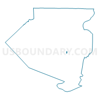
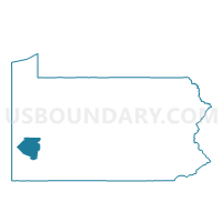
SWISSVALE DIST 07, Allegheny County, Pennsylvania
About
Outline

Summary
| Unique Area Identifier | 656804 |
| Name | SWISSVALE DIST 07 |
| County | Allegheny County |
| State | Pennsylvania |
| Area (square miles) | 0.12 |
| Land Area (square miles) | 0.11 |
| Water Area (square miles) | 0.01 |
| % of Land Area | 88.02 |
| % of Water Area | 11.98 |
| Latitude of the Internal Point | 40.42054340 |
| Longtitude of the Internal Point | -79.89524720 |
Maps

Graphs
Select a template below for downloading or customizing gragh for SWISSVALE DIST 07, Allegheny County, Pennsylvania


Neighbors
Neighoring Voting District (by Name) Neighboring Voting District on the Map
- MUNHALL DIST 01, Allegheny County, PA
- PITTSBURGH WD 14 DIST 19, Allegheny County, PA
- PITTSBURGH WD 14 DIST 27, Allegheny County, PA
- PITTSBURGH WD 14 DIST 28, Allegheny County, PA
- SWISSVALE DIST 08, Allegheny County, PA
- SWISSVALE DIST 09, Allegheny County, PA
Top 10 Neighboring County Subdivision (by Population) Neighboring County Subdivision on the Map
- Pittsburgh city, Allegheny County, PA (305,704)
- Munhall borough, Allegheny County, PA (11,406)
- Swissvale borough, Allegheny County, PA (8,983)
Top 10 Neighboring Place (by Population) Neighboring Place on the Map
Top 10 Neighboring Unified School District (by Population) Neighboring Unified School District on the Map
- Pittsburgh School District, PA (309,086)
- Woodland Hills School District, PA (46,882)
- Steel Valley School District, PA (16,500)
Top 10 Neighboring State Legislative District Lower Chamber (by Population) Neighboring State Legislative District Lower Chamber on the Map
- State House District 23, PA (61,207)
- State House District 34, PA (55,844)
- State House District 35, PA (53,932)
Top 10 Neighboring State Legislative District Upper Chamber (by Population) Neighboring State Legislative District Upper Chamber on the Map
Top 10 Neighboring 111th Congressional District (by Population) Neighboring 111th Congressional District on the Map
Top 10 Neighboring Census Tract (by Population) Neighboring Census Tract on the Map
- Census Tract 4843, Allegheny County, PA (3,404)
- Census Tract 5154.01, Allegheny County, PA (2,266)
- Census Tract 5153, Allegheny County, PA (1,871)
- Census Tract 1411, Allegheny County, PA (1,361)